Region:
North Yukon
Registration required:
Yes
Total sites:
51
Pull through:
1
Serviced:
May 3 to September 30, 2024
Gate open:
Gate open year-round
Warning:
Plan to arrive early as the vehicle sites often fill up. There may be space at the 12 walk-in tent sites.
Site description:
- Tombstone Mountain is one of the four road-accessible campgrounds with reservable campsites in 2024. Learn more.
- Often used as a base for driving the Dempster Highway or hiking into Tombstone Territorial Park.
- A short trail connects to the Tombstone Interpretive Centre. The centre offers free interpretive walks, talks and special events. The schedule is posted on site and on the park's Facebook page.
- Several trails begin at or near the campground.
- A 1 km, wheelchair-accessible interpretive trail leads from the centre to a beaver pond.
- A short interpretive loop called "Edge of the Arctic" through the tundra.
- A trail along the North Klondike River (Tr'ondëk).
- Grab the park brochure or view hike and camp in Tombstone Territorial Park for maps and more information on these and other day-hikes and routes.
Campground peak times:
May
June
July
August
September

Location
Highway:
Dempster Highway
Highway kilometre:
72.0
GPS coordinates:
64.50618°N 138.21991°W
Map download:
Tombstone Mountain Campground Map (1.18 MB)
Site directions:
0.5 km north of the Tombstone Interpretive Centre. A footpath also connects the two.
Services available
Outhouse unisex
Bear proof garbage bins
Blue bear-proof recycling bins
Picnic tables
Cook shelter
Fire ring
Bear proof cache
Hiking trails
At least one wheelchair accessible outhouse
At least one wheelchair accessible campsite
Hand pump or water tank provided
Viewing structures or signage about local cultural and natural history
Interpretive centre
Group campsite
Tent pads or sites available via walking trail
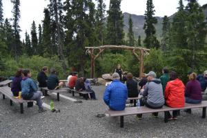
Outdoor amphitheater