Region:
Whitehorse
Registration required:
Yes
Total sites:
31
Pull through:
9
Serviced:
May 17 to September 30, 2024
Gate open:
May 17 to September 30, 2024
Warning:
This campground is often full on weekends.
Site description:
- Surrounded by open aspen forest.
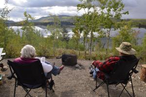
- Several sites look out over the lake.
- New walk-in tent sites.
- Great place to canoe, kayak, swim or fish.
- Loon calls are common.
- Several trails in the area. Download the trail map.
- The lake's Southern Tutchone name is Deghäl Shäw Män.
Campground peak times:
May
June
July
August
September

Location
Highway:
Klondike Highway
Highway kilometre:
308.0
GPS coordinates:
61.70464°N 135.9379°W
Map download:
Twin Lakes campground map (281.43 KB)
Services available
Outhouse unisex
Bear proof garbage bins
Picnic tables
Cook shelter
Fire ring
Boat launch
Boat dock
Hiking trails
At least one wheelchair accessible outhouse
At least one wheelchair accessible campsite
Hand pump or water tank provided
Viewing structures or signage about local cultural and natural history
Tent pads or sites available via walking trail